
Kentucky Power and Appalachian Power representatives plan to upgrade the electric transmission grid in Lawrence and Johnson counties, Kentucky and Wayne County, West Virginia.
The project involves:
The project team plans to rebuild in or near the existing right-of-way where possible and will seek new and supplemental easements to avoid encroachments, slides, and other constraints.
This project involves filing applications with the Kentucky Public Service Commission and the Public Service Commission of West Virginia.
September 2026: Company representatives are reviewing all materials submitted during the recent public notice period and plan to announce a proposed route later this year. The project team plans to file the project with both the PSC of West Virginia and the Kentucky PSC in 2027.
August 2026: Kentucky Power and Appalachian Power representatives announced the Big Sandy-Thelma Transmission Improvements Project. We plan to host in-person open houses in your area to provide an opportunity for residents to meet and talk with project representatives. Since there is no formal presentation, residents may join the planned events at any time.
Wednesday, August 26, from 5:00 p.m. - 7:00 p.m.
Louisa Senior Citizens Center
101 W. Pike Street, Louisa, KY
Thursday, August 27, from 5:00 p.m. - 7:00 p.m.
Paintsville High School
225 2nd Street, Paintsville, KY 41240
Also, we invite you to review this website and enter our virtual open house to learn more and share your feedback. For the virtual open house, please use Microsoft Edge, Google Chrome, Firefox, or Safari internet browsers for the best user experience. You may submit comments and questions about the project through the Contact form at the bottom of this page. Please share your input by Wednesday, September 2, 2026.
*Move slider to view project timeline
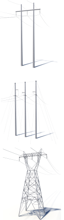
Crews plan to install steel H-frame, three-pole structures and lattice tower structures along the line route.
Current Structure Height: 60 - 80 feet*
Typical Structure Height: 80 - 120 feet*
Current Right-of-Way Width: 50 feet*
Typical Right-of-Way Width: Approximately 100 feet*
*Exact structure type, height and right-of-way requirements may vary
Please note that these maps are preliminary and do not reflect any final power line route decisions.
OVERVIEW MAP
Step 1: Below is an Overview Map that displays the entire project area. Please use the Overview Map to find the general location of your property.
DETAILED MAPS
Step 2: Each outlined area on the Overview Map represents a single, numbered Map Page that shows that section in greater detail. Visit the appropriate Map Page below for your area.
Project Outreach
833-760-0604
KentuckyPowerOutreach@AEP.com
